
US States Quiz
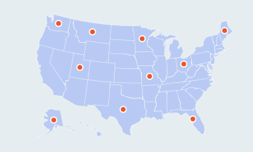
50 statesSmall places have round markers · Ctrl + scroll to zoomTwo fingers to pan and zoom
Click each of the 50 states on a blank map of the United States, from Alabama to Wyoming. Free, no sign-up.
What it does
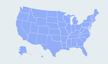
The US States Quiz is a free map game that asks you to find each of the 50 United States on a blank map. Each turn names a state and you click it; a wrong click highlights where it is. Practice mode repeats the states you miss until you place them, and timed mode records how fast you can place all fifty.
How to use it
- Find the named state
Click the state named above the map. Rhode Island has a round marker; tap near Delaware or Connecticut and the quiz picks the nearest small state.
- Choose a round
Play all 50 states or a Quick 15, in Practice or Timed mode.
- Drill your mistakes
At the end you see your score, your time and everything you missed. Press Practice the ones you missed to replay only those.
Limits and notes
- Alaska and Hawaii are drawn as insets in the lower left and are not to scale.
- Washington, D.C. and the US territories are not states and are not asked.
- Boundaries come from the US Census Bureau cartographic files via us-atlas, simplified so the map loads fast.
- Scores and best times are kept only in this browser. Clearing site data resets them.
More about the US States Quiz
The states are grouped by the four US Census Bureau regions. After each round the results panel shows the region where you missed the most.
Northeast (9)
Connecticut, Maine, Massachusetts, New Hampshire, New Jersey, New York, Pennsylvania, Rhode Island, Vermont.
Midwest (12)
Illinois, Indiana, Iowa, Kansas, Michigan, Minnesota, Missouri, Nebraska, North Dakota, Ohio, South Dakota, Wisconsin.
South (16)
Alabama, Arkansas, Delaware, Florida, Georgia, Kentucky, Louisiana, Maryland, Mississippi, North Carolina, Oklahoma, South Carolina, Tennessee, Texas, Virginia, West Virginia.
West (13)
Alaska, Arizona, California, Colorado, Hawaii, Idaho, Montana, Nevada, New Mexico, Oregon, Utah, Washington, Wyoming.
Frequently asked questions
How many states are there in the United States?
Fifty. Washington, D.C. is a federal district, and Puerto Rico, Guam and the other territories are not states.
Which states are hardest to click?
The small ones in the Northeast: Rhode Island, Delaware, Connecticut, New Jersey, Massachusetts, Vermont and New Hampshire. Zoom in or tap close to them.
Are Alaska and Hawaii shown to scale?
No. Like most US maps, this one moves them into insets so the 48 contiguous states can be drawn large. Alaska is in fact the largest state by far.
Is my score saved?
Your best score and time for each mode are saved in this browser only. There is no account and nothing is sent to a server.