
Oceania Map Quiz
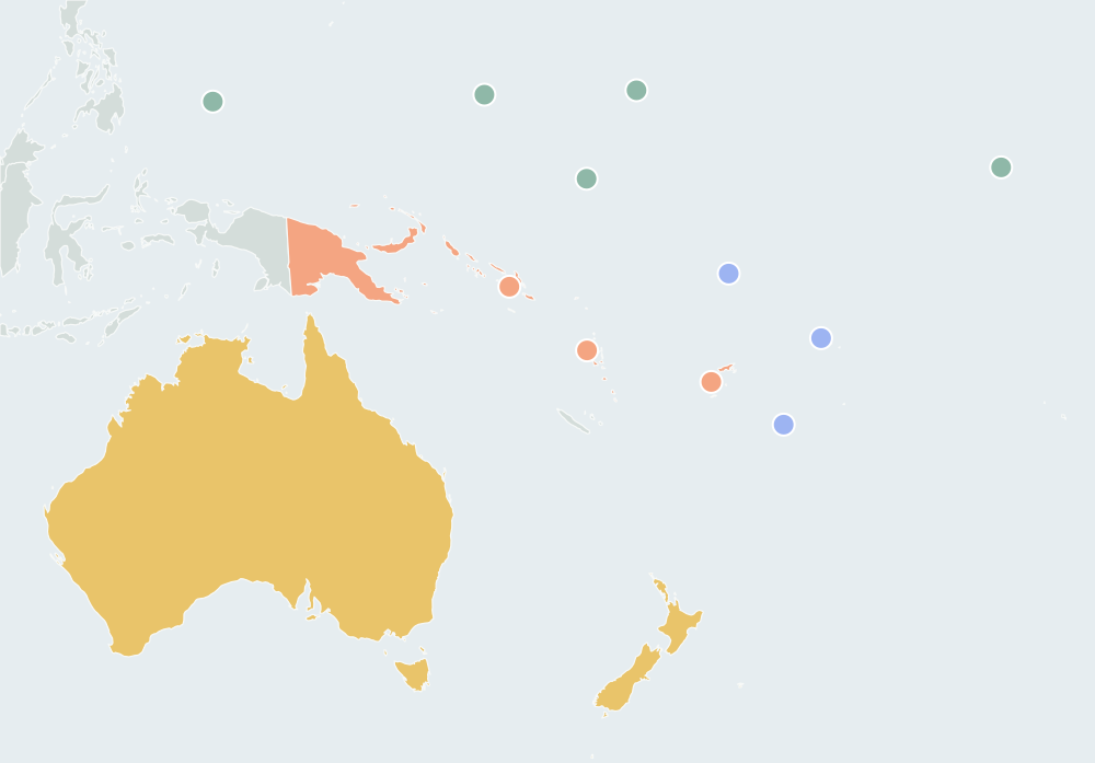
14 countriesSmall places have round markers · Ctrl + scroll to zoomTwo fingers to pan and zoom
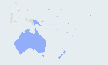
Find every country of Oceania on a blank map, the small Pacific island nations included. Play all 14 or one region at a time. Free, no sign-up.
How many countries are in Oceania?
This map game asks the 14 independent countries of Oceania, all of them UN members. Lists of "countries and territories" add places governed by other countries, such as New Caledonia, French Polynesia, Guam and American Samoa, and the Cook Islands and Niue, which are in free association with New Zealand. Those are not asked.
- 14countries asked
- 4UN regions
- Australialargest by area
- Naurusmallest, about 21 km²
The countries of Oceania by region
The quiz follows the four regions of the UN geoscheme. Each region can be played on its own from the region menu, and after a full round the result names the region you missed most.
Australia and New Zealand2
Australia, New Zealand
Melanesia4
Fiji, Papua New Guinea, Solomon Islands, Vanuatu
Micronesia5
Kiribati, Marshall Islands, Micronesia, Nauru, Palau
Polynesia3
Samoa, Tonga, Tuvalu
Hardest countries of Oceania to find
Australia, Papua New Guinea and New Zealand are easy to click. Most misses are the island nations, which are too small to see at full size and have rings instead. Tap a ring, or zoom in; when two rings are close together, the map zooms in for you.
- The smallest islandsNauru is one island of about 21 km², and Tuvalu is nine small islands and atolls. Both lie south of the equator.
- North of the equatorPalau, Micronesia and the Marshall Islands run from west to east across the Micronesia region, far from any large land.
- KiribatiIts 33 islands spread across the equator and both sides of the 180° meridian. The ring sits on one of its island groups; a click on any of its islands counts.
Countries people mix up
- Micronesia (country) · Micronesia (region)
- The country is the Federated States of Micronesia, north of Papua New Guinea and the Solomon Islands. The region also takes in Palau, the Marshall Islands, Nauru and Kiribati.
- Solomon Islands · Marshall Islands
- The Solomon Islands are the chain just east of Papua New Guinea, south of the equator. The Marshall Islands are atolls far to the north-east, north of the equator.
- Fiji · Tonga · Samoa
- Fiji is the westernmost of the three. Tonga lies to its south-east, and Samoa to its north-east. Tuvalu is due north of Fiji.
- Samoa · American Samoa
- Samoa is the independent country, the western islands. American Samoa, just to the east, is a United States territory and is not asked.
How to learn the map of Oceania
- Start with the anchors: Australia, Papua New Guinea and New Zealand. Every other country lies in the Pacific to their north and east.
- Follow the Melanesian arc from Papua New Guinea south-east through the Solomon Islands and Vanuatu to Fiji. Then place Tuvalu, Samoa and Tonga around Fiji.
- Go west to east above the equator Palau, Micronesia and the Marshall Islands, with Nauru and Kiribati on the equator south of them.
- Play one region at a time from the region menu, then replay only your misses with Practice the ones you missed. Race the clock in Timed mode once a full round is clean.
Other names you may know
The quiz uses short English names. Micronesia is the Federated States of Micronesia. Kiribati, the former Gilbert Islands, is pronounced "Kiribas". Tuvalu was the Ellice Islands, Vanuatu was the New Hebrides until 1980, Samoa was Western Samoa until 1997, and Nauru was once called Pleasant Island.
Questions
Are Hawaii, New Caledonia and Guam asked?
No. Hawaii is a US state, Guam a US territory and New Caledonia a French territory, and none of them is asked. The quiz asks only independent countries; territories inside the map, such as New Caledonia, are drawn as background.
Are the Cook Islands and Niue countries?
They govern themselves in free association with New Zealand but are not UN member states, so they are not asked. The quiz counts the 193 UN members plus Vatican City and Palestine.
Are Indonesia and Timor-Leste in Oceania?
The UN places both in South-eastern Asia, so they are asked in the Asia Map Quiz. Western New Guinea, which belongs to Indonesia, is drawn as background next to Papua New Guinea.
Why is the map centred on the Pacific?
Fiji and Kiribati lie on both sides of the 180° meridian. Centring the map on the Pacific keeps them in one piece instead of splitting them across the edges.
Where does the map come from?
The borders come from Natural Earth at 1:50m scale, a public-domain dataset, simplified so the map loads fast.
Scores stay in this browser. How AtlasWhiz saves your progress