
Caribbean Map Quiz
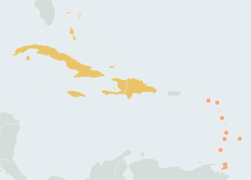
13 countriesSmall places have round markers · Ctrl + scroll to zoomTwo fingers to pan and zoom
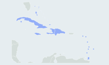
Find every country of the Caribbean islands on a blank map, from the Bahamas to Trinidad and Tobago. Play all 13 or one island group at a time. Free, no sign-up.
How many countries are in the Caribbean?
This map game asks the 13 countries of the Caribbean, all of them island nations and UN members. Puerto Rico, the Cayman Islands, Guadeloupe, Martinique, Aruba, Curaçao and the other territories are drawn on the map but not asked.
- 13countries asked
- 2countries on one island, Hispaniola
- Cubalargest by area, about 110,000 km²
- Saint Kitts and Nevissmallest, about 261 km²
The Caribbean countries by island group
The quiz splits the islands into two groups. Each can be played on its own from the region menu, and after a full round the result names the group you missed most.
The Bahamas and the Greater Antilles5
Bahamas, Cuba, Dominican Republic, Haiti, Jamaica
The Lesser Antilles8
Antigua and Barbuda, Barbados, Dominica, Grenada, Saint Kitts and Nevis, Saint Lucia, Saint Vincent and the Grenadines, Trinidad and Tobago
Hardest Caribbean countries to find
Cuba, Hispaniola and Jamaica are easy to spot. Seven of the eight Lesser Antilles countries are too small to click at full size and have rings instead; the rings sit on the islands in their real order. Tap a ring, or zoom in; when two rings are close together, the map zooms in for you.
- Saint Lucia and Saint VincentThe two closest rings on the map. Saint Lucia is the northern one, just south of the French island of Martinique; Saint Vincent and the Grenadines lies directly south of it.
- BarbadosThe one country off the chain. It sits alone in the Atlantic, more than 150 km east of Saint Vincent, so look east of the arc, not on it.
- Saint Kitts and NevisThe smallest country in the Americas and the westernmost of the Lesser Antilles countries. It lies west of Antigua and Barbuda and south of the islands of Anguilla and Saint Martin, which are territories.
Countries people mix up
- Dominica · Dominican Republic
- The Dominican Republic is the eastern part of Hispaniola, the large island it shares with Haiti. Dominica is a single small island in the Lesser Antilles, between Guadeloupe and Martinique.
- Grenada · Saint Vincent and the Grenadines
- The Grenadines are the small islands between Saint Vincent and Grenada. The northern ones belong to Saint Vincent and the Grenadines; Carriacou and Petite Martinique, the southern ones, belong to Grenada.
- Saint Kitts and Nevis · Antigua and Barbuda
- Both are two-island countries in the Leeward Islands. Saint Kitts and Nevis is the western one; Antigua and Barbuda lies to its east, with Barbuda well to the north of Antigua.
- Haiti · Dominican Republic
- Haiti is the western third of Hispaniola, the side that faces Cuba and Jamaica. The Dominican Republic is the larger eastern part, facing Puerto Rico.
How to learn the map of the Caribbean
- Start with the big islands: Cuba, the Bahamas to its north, Jamaica to its south, then Hispaniola, split between Haiti in the west and the Dominican Republic in the east.
- Follow the arc of the Lesser Antilles from north to south past Puerto Rico. Saint Kitts and Nevis, Antigua and Barbuda, Dominica, Saint Lucia, Saint Vincent and the Grenadines and Grenada.
- Add the two outliers Barbados alone to the east, and Trinidad and Tobago at the southern end, just off the coast of Venezuela.
- Practice one island group at a time from the region menu. In Practice mode there is no clock; at the end of a round, replay only your misses with Practice the ones you missed, then race the clock in Timed mode or hide the borders.
Other names you may know
The quiz uses short English names. Bahamas is officially The Bahamas. Saint Kitts and Nevis is also called Saint Christopher and Nevis, and the Saints are often written St. The Caribbean islands are also called the West Indies, and the island chains the Antilles. In the Lesser Antilles, Saint Kitts and Nevis and Antigua and Barbuda are in the Leeward Islands; Saint Lucia, Saint Vincent and the Grenadines and Grenada are in the Windward Islands.
Questions
Are Puerto Rico, Aruba and Curaçao asked?
No. Puerto Rico and the US Virgin Islands are US territories; Aruba, Curaçao and Sint Maarten are countries within the Kingdom of the Netherlands; Guadeloupe and Martinique are part of France; and the Cayman Islands, Anguilla, Montserrat, the British Virgin Islands and the Turks and Caicos Islands are British overseas territories. None is an independent country, so they are drawn but not asked.
Are the Bahamas in the Caribbean?
The Bahamas lie in the Atlantic Ocean, north of Cuba, not in the Caribbean Sea. The UN groups them with the Caribbean, as do most maps of the West Indies, so they are in this quiz.
Why are Belize, Guyana and Suriname not in the quiz?
They belong to the Caribbean Community, but they are on the mainland. This quiz asks the island countries. Belize is in the Central America Map Quiz, and Guyana and Suriname are in the South America Map Quiz.
How does the quiz handle such small islands?
The borders come from Natural Earth at 1:50m scale, a public-domain dataset. Islands too small to click get a ring around them, and a tap anywhere in the ring counts. You can also zoom in with two fingers or the zoom buttons, or play full screen.
Scores stay in this browser. How AtlasWhiz saves your progress