
Canada Provinces Quiz
13 provinces & territoriesSmall places have round markers · Ctrl + scroll to zoomTwo fingers to pan and zoom
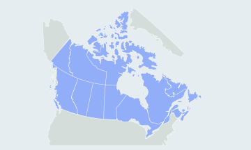
Find each of Canada's 10 provinces and 3 territories on a blank map of Canada, from Yukon to Newfoundland and Labrador. Free, no sign-up.
How many provinces and territories does Canada have?
Canada has 10 provinces and 3 territories, and this map quiz asks all 13. The quiz names a province or territory, you click it on a blank map, and a wrong click shows where it is.
- 13places asked
- 10provinces
- 3territories
- Nunavutlargest; Prince Edward Island the smallest
The provinces and territories by region
The quiz asks all 13 in one round. To learn them, this page splits Canada into five regions, from the Pacific coast across the Prairies to the Atlantic, with the three territories in the north.
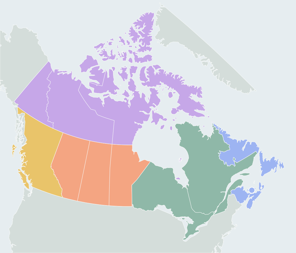
West Coast1
British Columbia
Prairies3
Alberta, Manitoba, Saskatchewan
Central Canada2
Ontario, Quebec
Atlantic Canada4
New Brunswick, Newfoundland and Labrador, Nova Scotia, Prince Edward Island
Northern territories3
Northwest Territories, Nunavut, Yukon
Hardest provinces and territories to find
The western half of the map is easy once you know the order. Most misses happen in the small Atlantic provinces and along the line between the two eastern territories.
- Prince Edward IslandThe smallest province, an island in the Gulf of St. Lawrence north of Nova Scotia and east of New Brunswick. It has a round marker so you can click it without zooming.
- Nova Scotia and New BrunswickNew Brunswick is on the mainland, between Quebec and the US state of Maine. Nova Scotia is the peninsula to its south-east, joined by a narrow isthmus, plus Cape Breton Island.
- Nunavut and the Northwest TerritoriesNunavut is the eastern part and takes in most of the Arctic islands, including Baffin Island. The Northwest Territories lie to the west, between Yukon and Nunavut, above Alberta and Saskatchewan.
Provinces people mix up
- Saskatchewan · Manitoba
- Saskatchewan is the middle Prairie province, with straight borders and no coast. Manitoba is east of it and reaches Hudson Bay.
- Alberta · British Columbia
- British Columbia is on the Pacific coast. Alberta is east of it, across the Rocky Mountains, and is landlocked like Saskatchewan.
- Newfoundland · Labrador
- One province in two parts. Newfoundland is the island; Labrador is the mainland part to its north-west, next to Quebec.
How to learn the map of Canada
- Go west to east along the US border: British Columbia, Alberta, Saskatchewan, Manitoba, Ontario, Quebec, then New Brunswick.
- Add the Atlantic provinces: Nova Scotia south-east of New Brunswick, Prince Edward Island between them, and Newfoundland and Labrador to the north-east.
- Finish in the north: Yukon next to Alaska, the Northwest Territories in the middle, and Nunavut in the east with the Arctic islands.
- Practice on the blank map: in Practice mode there is no clock. At the end of a round, replay only the places you missed with Practice the ones you missed, then race the clock in Timed mode or hide the borders.
Other names you may know
The quiz uses English names. Quebec is Québec in French. Newfoundland and Labrador was called Newfoundland until 2001. Yukon was officially the Yukon Territory until 2003. Nunavut was split from the Northwest Territories in 1999. New Brunswick, Nova Scotia and Prince Edward Island together are the Maritimes; with Newfoundland and Labrador they make up Atlantic Canada.
Questions
Does Canada have states?
No. Canada is divided into 10 provinces and 3 territories, and this quiz asks all 13. Searches for a "Canada states quiz" usually mean this map.
What is the difference between a province and a territory?
Provinces hold powers of their own under Canada's Constitution. Territories exercise powers delegated by the federal Parliament.
Which provinces and territories border the United States?
Seven provinces, British Columbia, Alberta, Saskatchewan, Manitoba, Ontario, Quebec and New Brunswick, plus Yukon, which borders Alaska. Nova Scotia, Prince Edward Island, Newfoundland and Labrador, the Northwest Territories and Nunavut have no land border with the US.
Which province joined Canada last?
Newfoundland, in 1949. Ontario, Quebec, Nova Scotia and New Brunswick formed Canada in 1867; Nunavut, created in 1999, is the newest territory.
Where does the map come from?
The boundaries come from Natural Earth at 1:50m scale, a public-domain dataset, simplified so the map loads fast. The smallest Arctic islands are left out.
Scores stay in this browser. How AtlasWhiz saves your progress